By Mustafa Jawaad, General Manager, XRTech Group
Quick answer: Google Earth gets its images from three main sources. Commercial imaging satellites run by companies such as Vantor (formerly Maxar) and Airbus supply most of the detailed views, at about 30 to 50 cm per pixel. Aircraft flown by Google and by aerial survey firms photograph cities at even finer detail and supply the 3D buildings. Free government satellites such as Landsat and Copernicus Sentinel-2 fill in the zoomed-out globe. Google licenses these photos, removes clouds and colour differences, and stitches them into one seamless map. Google Maps satellite view uses the same imagery. Because it is a mosaic, the picture of any place is usually months to several years old, not live.
Google does not operate its own imaging satellites, so every Google Earth picture you look at was captured by someone else's satellite or plane, then licensed and processed by Google. Knowing where those pictures come from explains almost everything people ask about Google Earth: why one street is sharp and the next is blurry, why the image is years old, why colours change at a line across a field, and why you cannot just download it for a project. At XRTech Group we sell imagery from the same class of satellites Google licenses, so this guide also shows where Google Earth ends and commercial satellite imagery begins, and which one fits your purpose.
Where Does Google Earth Get Its Images?
Google satellite images are really a blend of satellite and aerial photos from many suppliers. The source changes with your zoom level and your location:
Source
Typical detail
Where you see it
Examples
Commercial satellites
30 to 60 cm per pixel
Most towns and countryside worldwide
Vantor WorldView and GeoEye, Airbus Pléiades and SPOT (credited as CNES / Airbus)
Aircraft (aerial photography)
Often finer than 15 cm
Large cities and suburbs, and the 3D buildings
Google's own and contracted survey planes, Vexcel Imaging, national programmes such as USDA NAIP
Free government satellites
10 to 30 m per pixel
The zoomed-out globe, deserts, oceans and polar areas
Landsat (NASA and USGS), Copernicus Sentinel-2 (ESA)
Street-level cameras
360° ground photos
Street View
Google cars and trekkers, user-contributed photos
Elevation data
Terrain shape, not a photo
Hills, mountains and valleys under the imagery
Radar and lidar elevation models, such as the SRTM dataset
You can see who supplied the picture you are looking at. In Google Earth, check the credit line and the Data attribution link in the bar at the bottom of the screen. In Google Maps, the line starting with "Imagery ©" at the bottom right names the providers. Credits such as CNES / Airbus, Vantor, Landsat / Copernicus or an aerial firm tell you whether you are looking at satellite or aircraft imagery.
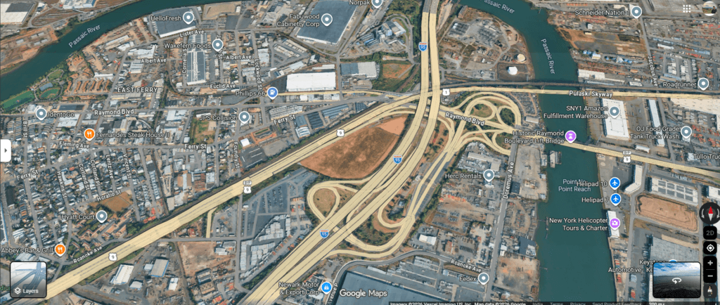
Google Maps satellite view over Newark, New Jersey. The credit at the bottom right reads Vexcel Imaging, an aerial photography company, so this sharp view was taken from a plane, not a satellite. More on the difference in aerial vs satellite imagery.
How Google Turns Raw Photos Into the Google Earth Map
A satellite photo straight from orbit looks nothing like the smooth globe you spin in Google Earth. Before a picture goes live, Google processes it in several steps:
- Selection: Google picks the clearest licensed image for each area, favouring recent, cloud-free and high-detail captures.
- Orthorectification: each photo is corrected for camera tilt and terrain, so roads and buildings sit in the right place on the map.
- Cloud and haze removal: an AI model called Cloud Score+ flags clouds, shadows, haze and mist so cleaner pixels can be used instead.
- Colour balancing: brightness and colour are matched so neighbouring images blend together. Where this fails, you see a visible seam or a sudden colour change.
- Mosaicking: thousands of images taken on different days are stitched into one continuous layer. That is why a single screen can mix captures from different months or years.
- 3D modelling: in many cities, aircraft photograph the same streets straight down and from 45° angles. Photogrammetry software matches those overlapping photos to build the textured 3D buildings and trees.
Google Earth vs Google Maps Satellite View: Same Images?
Yes. The Google Maps satellite image and the Google Earth map satellite view come from the same imagery library, so your street looks the same in both. The difference is the tool around it. Google Earth adds historical imagery, a timeline, measuring tools and a full 3D globe, while Google Maps adds directions, place details and Street View in a simpler map. If you mostly use Maps, our guide to Google Maps satellite view shows how to switch it on and get the clearest picture.
How Old Are Google Earth Images?
Google updates imagery on no fixed schedule. How old Google Earth pictures are depends mainly on how many people look at an area and how often planes or satellites are paid to capture it. As a rough guide:
Area
Typical age of the newest image
Why
Major cities
About 1 to 3 years
High demand and regular aerial flights
Suburbs and towns
About 2 to 5 years
Covered by satellite refreshes, less often by planes
Rural and remote land
Often 3 to 10 years or more
Low demand, so older satellite images stay in place
Oceans, deserts and polar areas
Refreshed periodically, but at low detail
Built from free 10 to 30 m satellite mosaics
These are typical ranges, not guarantees, and the date can differ between two neighbouring tiles. Google Earth shows a date for flat imagery where the provider supplied one, but shows no date for 3D views, because they are built from flights on several days. To find the exact date for your own street, follow the steps in how to see your house on Google Earth. And no, there is no live view: we explain why in can I see a live satellite view of my house.
How Accurate Is Google Earth?
Accuracy has two parts: how much detail you can see (resolution) and how close each point is to its true position on the ground (positional accuracy). Google publishes neither, so independent researchers have measured it against surveyed points:
Study area
Measured horizontal error (RMSE)
What it tells you
Global sample, 436 points
39.7 m on average, from 0.4 m to 171.6 m
Early archive. Satellite-based points (22.8 m) beat aerial ones (41.3 m), and developed countries beat developing ones
Riyadh, Saudi Arabia
2.18 m
Modern urban imagery is far better than the early archive
Big Bend, Texas, USA
2.64 m
Good in open terrain, still not survey grade
Rural Tamaulipas, Mexico
4.5 m
Rural areas tend to be less accurate
In short, Google Earth is usually within a few metres in well-covered areas and can be tens of metres off in older or remote imagery. That is fine for finding a place, but not for boundaries, engineering or legal use. By comparison, leading 30 cm commercial satellites are specified at roughly 3.5 to 5 m CE90 straight from the satellite, and can reach under 1 m when corrected with ground control points. Our guide to CE90 horizontal accuracy explains how that is measured. If your view looks soft rather than misplaced, see why Google Earth is blurry.
What Google Earth Pictures Cannot Do
- No choice of date: you see whatever Google has licensed, and you cannot order a new capture of your area.
- No raw data: you get a screen view, not a georeferenced GeoTIFF with capture metadata, so it cannot go straight into GIS or CAD.
- Natural colour only: there are no near-infrared or multispectral bands for crop health, water or vegetation analysis.
- Mixed dates: a mosaic can join images from different years, which is risky for evidence or change detection.
- Limited rights: Google's geo guidelines allow some uses with attribution, such as presentations or editorial use, but not reselling the imagery or using it as source data for paid products.
Google Earth vs Commercial Satellite Imagery: Comparison
Here is how free Google satellite images compare with free government data and paid commercial imagery:
Feature
Google Earth
Free satellites (Sentinel-2, Landsat)
Commercial imagery (XRTech Group)
Best detail
Aerial in big cities, 30 to 60 cm elsewhere, coarse in remote areas
10 m (Sentinel-2) to 30 m (Landsat)
Down to 30 cm optical, plus radar
Capture date
Not always shown, mosaics mix dates
Exact date and time
Exact date and time on every image
How current
Months to years old
New image every few days
Days-old archive, or a new capture ordered for your dates
Choose area and time
No
No, fixed orbits
Yes, through satellite tasking
File you get
Screen view or screenshot
Free GeoTIFF download
Orthorectified GeoTIFF with metadata, or raw with RPC
Bands
Natural colour
Multispectral (13 bands on Sentinel-2)
Colour, near-infrared, multispectral, stereo, SAR
Use rights
Limited, with attribution
Open licence
Licensed for your project
Cost
Free
Free
From about USD 20 per km² (30 cm archive)
Commercial Satellite Imagery Providers Compared
Google licenses from some of these operators. Buying direct, or through a supplier like XRTech Group, gives you the full-quality file and a known date:
Provider
Key satellites
Best resolution
Known for
Vantor (formerly Maxar Intelligence)
WorldView Legion, WorldView-3
30 cm
Deep archive and frequent revisits over busy areas
Airbus
Pléiades Neo, Pléiades, SPOT
30 cm
Wide coverage, from 30 cm detail to 1.5 m regional SPOT
Siwei
SuperView Neo-1, SuperView-1
30 cm
Competitive pricing and stereo for 3D models
Planet
SkySat, PlanetScope
50 cm (SkySat), about 3 m (PlanetScope)
Near-daily coverage of the land surface at 3 m
ESA Copernicus
Sentinel-2, Sentinel-1
10 m
Free multispectral and radar data
NASA and USGS
Landsat 8 and 9
30 m (15 m panchromatic)
Free archive spanning more than 50 years for long-term change
XRTech Group sources imagery from a network of more than 130 optical and radar satellites, so we can quote the best sensor for your area, date and budget rather than a single brand. For the full list of operators, see our guide to every commercial imaging satellite, and for free options, where to get high-quality satellite images for free.
Which Should You Choose? Best Source for Each Purpose
Match the source to the job:
Your goal
Best source
Why
Look at your home, plan a trip, explore
Google Earth or Google Maps
Free, instant and good enough to recognise places
See how a place changed over decades
Google Earth historical imagery, Landsat
Long archives at no cost
Monitor crops, forests or water every week
Sentinel-2, or commercial multispectral
Frequent captures with near-infrared bands
Track construction progress
Commercial 30 to 50 cm tasking
You set the dates and see each stage clearly
Insurance claims and disaster damage
Commercial post-event optical plus SAR
Dated proof, and radar sees through cloud and smoke
Legal, boundary or due diligence evidence
Commercial archive with metadata
Verifiable capture date and licensed use
GIS mapping and engineering
Orthorectified commercial imagery with ground control
Known accuracy and files that load straight into GIS
3D city models, terrain and volumes
Commercial stereo or tri-stereo imagery
Builds DSMs, DEMs and 3D models you own
Other Google Imagery Services Worth Knowing
- Google Earth Pro: the free desktop app, with historical imagery, image dates, measuring and higher-resolution image export.
- Google Earth Engine: a cloud platform for analysing Landsat, Sentinel and other public datasets at scale, free for research and non-commercial use and paid for business.
- Gemini in Google Earth: AI features that let professional users ask questions about places and find objects in imagery, rolling out first in the US to paid plans.
- Google Maps Platform: developer APIs, including photorealistic 3D tiles built from the same aerial data as Google Earth's 3D cities.
- Street View: ground-level 360° photos, now viewable with older dates inside Google Earth as well as Maps.
Need More Than Google Earth? Buy the Original Satellite Image
Google Earth shows a processed, mixed-date view. XRTech Group delivers the original 30 cm satellite image of your area as a GeoTIFF with its exact capture date and licence, from archive or a new capture. Compare the two below, then search your area or ask our team for a free quote.
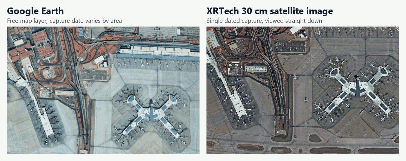
Same airport, two sources: the Google Earth layer (left) and an XRTech 30 cm satellite image (right), with sharper aircraft, gates and markings.
Frequently Asked Questions
Does Google have its own satellites for Google Earth?
No. Google briefly owned an imaging satellite company, Skybox (later Terra Bella), but sold it to Planet and now licenses imagery instead. Its own contribution is aerial photography from planes and Street View from cars and trekkers.
Are Google Earth pictures real photos?
Yes. The flat imagery is made of real satellite and aerial photos, colour balanced and stitched together. The 3D buildings are computer models built from real overlapping aerial photos, which is why they can look melted at the edges.
Who takes the pictures for Google Earth?
Satellite operators such as Vantor and Airbus, aerial survey firms and Google's own camera planes, government programmes like Landsat and Sentinel-2, and Google's Street View teams. The credit line on screen names the providers for the area you are viewing.
Can I use Google Earth images in a report or for business?
Only within Google's geo guidelines, which allow some uses such as presentations and editorial content with Google and provider attribution. For commercial products, analysis or legal evidence you need licensed imagery with a known date.
Can I download full-resolution Google Earth images?
No. Google Earth Pro can save a larger picture of the screen, but it is not a georeferenced file and has no capture metadata. For a GeoTIFF you can measure and map with, you need the original image from a satellite provider.
Does Google Earth use drones?
Not for its base map. Google Earth imagery comes from satellites and crewed aircraft. You can add your own drone maps as overlays, but they stay in your project.
Can I ask Google to update the image of my area?
You can send feedback through Google's outdated imagery form, but Google does not promise a date. If you need a new picture on a set date, order a commercial satellite capture.
What is the highest resolution in Google Earth?
The sharpest views are aerial photos over big cities, finer than any satellite. Where satellites are the source, detail tops out around 30 cm per pixel, the best that commercial imaging satellites currently sell.
Sources
- Google Earth Help: How images are collected
- Google: Imagery updates to Google Earth and Maps, including Cloud Score+
- Potere, Sensors: Horizontal positional accuracy of Google Earth's high-resolution imagery archive
- ISPRS Archives: Horizontal accuracy assessment of Google Earth data
- Vantor: Maxar Intelligence becomes Vantor
- Gizmodo: Google's fleet of airplanes for 3D mapping

Mustafa Jawaad
General Manager, XRTech Group
Mustafa helps governments and critical industries get satellite and UAV data in days rather than weeks, from archive search and new satellite tasking to processed maps, so teams can plan infrastructure faster and with less risk. Connect on LinkedIn.